The Pinnacle of Integrated AI for Reservoir Modeling software within subsurfaceAI
geomodelingAI, a premier feature of the subsurfaceAI platform, represents a groundbreaking advancement in AI for reservoir modeling software and analysis. This powerful tool synergistically combines the capabilities of SBED (Sedimentary BEDding) and ReservoirStudio software, offering an unparalleled, integrated environment for multi-scale and cross-scale modeling of full-field reservoirs. Below is an expanded description of geomodelingAI’s key features, showcasing its unique position in the industry.
Benefits of geomodelingAI
- Seamless Multi-Scale and Cross-Scale Modeling: geomodelingAI stands out for its ability to facilitate seamless multi-scale and cross-scale modeling. This functionality allows users to integrate data and insights across different scales, from the microscopic details captured by SBED to the broader reservoir perspectives offered by ReservoirStudio, all within a single, cohesive environment.
- Integration of Sub-Seismic and Sub-Cell Geological Heterogeneity: Unique in the industry, geomodelingAI is the only solution capable of rigorously integrating sub-seismic and sub-cell geological heterogeneity into reservoir models. This capability ensures that even the most minute geological variations are accurately represented in the models, leading to a more comprehensive understanding of reservoir behavior.
- Part of the AI-Infused subsurfaceAI Platform: As an integrated component of subsurfaceAI, geomodelingAI benefits from the platform’s AI-infused capabilities, particularly in seismic interpretation workflows. This integration of AI enhances the accuracy and efficiency of interpreting seismic and well data, providing a solid foundation for reservoir modeling.
- Rapid Turnaround from Data to Models: One of the most significant advantages of geomodelingAI is its ability to provide a fast turnaround from seismic and well data to detailed reservoir models. This speed is crucial in dynamic industry environments, where timely decision-making can significantly impact project success and resource management.
- Enhanced Decision-Making in Reservoir Management and Risk Assessment: With geomodelingAI, teams are empowered to make faster and more informed decisions in reservoir management and risk assessment. The tool’s comprehensive modeling capabilities, combined with its rapid data processing and AI-enhanced interpretations, provide users with a deep and nuanced understanding of their reservoirs, enabling more effective decision-making and risk mitigation.
In conclusion, geomodelingAI within subsurfaceAI stands as a pioneering solution in reservoir modeling, setting new standards in the industry. Its unique ability to integrate detailed geological heterogeneity, coupled with AI-driven workflows and efficient data processing, makes it an invaluable asset for any organization seeking to optimize its approach to reservoir management and modeling.
Enhancing Reservoir Insight
A Detailed Workflow Description
geomodelingAI, a sophisticated component of the subsurfaceAI platform, offers a comprehensive workflow for advanced reservoir modeling. This workflow integrates the strengths of SBED and ReservoirStudio, providing a seamless, multi-scale approach to reservoir characterization. Below is an expanded and detailed description of the key steps in geomodelingAI’s workflow, demonstrating its cutting-edge capabilities:
- Horizon Surface Modeling: The workflow initiates with the construction of 2-D surface grids. These grids are based on well tops or seismic horizon interpretations, utilizing both deterministic and geostatistical interpolation algorithms. This step ensures a highly accurate representation of the reservoir’s structural framework, forming the basis for subsequent modeling processes.
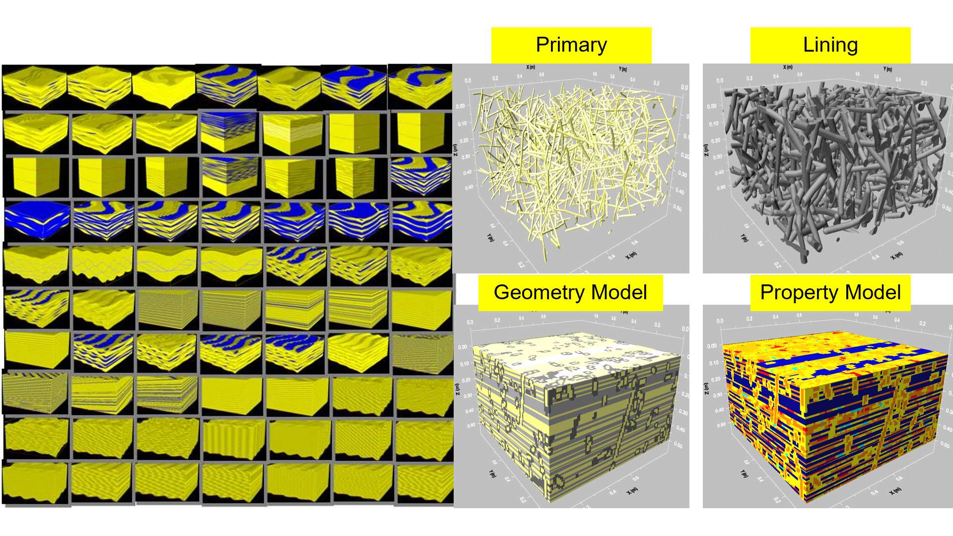
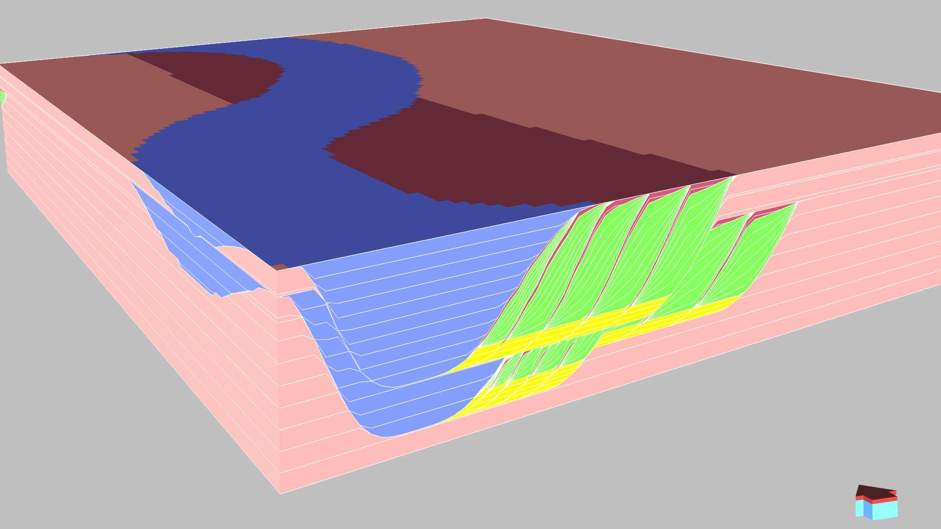
- Stratigraphic Scenario Modeling: geomodelingAI enables users to perform detailed stratigraphic scenario modeling by selecting appropriate templates in ReservoirStudio. This feature includes:
- Specialized modeling for both fluvial and deep-water reservoirs.
- A variety of model templates to accurately represent point-bars, channel-infill, and stacking patterns.
- The flexibility to model intricate geological features such as thin-bedded shale drapes and channel boundaries, ensuring a comprehensive and realistic stratigraphic representation.
- Facies Modeling: The software generates multiple realizations of facies grids using advanced geostatistical algorithms. It ensures that the upscaling of facies logs at well locations is accurately reflected in the models, leading to a nuanced understanding of the reservoir’s facies distribution.
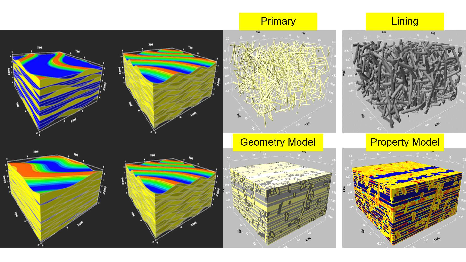
- SBED Near-Wellbore Modeling: geomodelingAI performs in-depth SBED near-wellbore modeling for all wells. This process involves deriving directional permeability data along the wellbore within the modeling zone, providing critical insights into the dynamic properties of the reservoir near the wellbore areas.
- Property Modeling: The software creates multiple realizations of porosity and permeability grids through sequential Gaussian simulation or machine learning algorithms. Users have the flexibility to apply porosity and permeability trends from well data or seismic attributes. Optional algorithms like universal kriging and collocated cokriging are available for generating a “best estimate” as a benchmark against stochastic realizations. Additionally, oil and gas saturation grids are generated based on the relationships between saturation, porosity, and permeability, or through direct simulation, with well conditioning data being honored in each grid.
- Volumetric Uncertainty Quantification: Users can select specific contact surfaces (oil-water, gas-water) for volumetric calculations in conventional reservoirs, as well as define polygons and target zones. The software calculates oil and gas volumes in place for each realization and plots histogram distribution curves of Original Gas In Place (OGIP), indicating P10, P50, and P90 or any user-defined percentile. This step is essential for accurately assessing and managing the uncertainties in reservoir estimates.
- Upscaling of Geo-Grid to Flow-Grid: geomodelingAI allows users to define a target grid with fewer cells for upscaling purposes. The software employs methods such as volumetric averaging for porosity grids and options like arithmetic, harmonic averaging, and “flow-based” methods for permeability grids. Additionally, it ensures the preservation of key geological features, such as mud layers in inclined heterolithic stratification (IHS), during the upscaling of facies properties.
In summary, geomodelingAI’s workflow offers a uniquely integrated, sophisticated, and comprehensive approach to reservoir modeling. Its capabilities in horizon surface modeling, stratigraphic scenario modeling, facies analysis, near-wellbore modeling, property simulation, uncertainty quantification, and upscaling make it an invaluable tool for geoscientists and reservoir engineers seeking to enhance their understanding and management of reservoirs.
Discover the Transformative Benefits
geomodelingAI for Reservoir Analysis
geomodelingAI, a key feature within the subsurfaceAI platform, offers an array of significant benefits for geoscientists and reservoir engineers. By integrating the capabilities of SBED and ReservoirStudio, augmented with AI, this advanced tool delivers unparalleled efficiency and accuracy in reservoir modeling. Here’s an expanded and polished overview of the major benefits of using geomodelingAI:
- Extensive Template Library: geomodelingAI provides access to over 100 templates specifically designed for both clastic and carbonate reservoirs. This extensive collection ensures that users can accurately model a wide range of geological settings, tailoring their analyses to the unique characteristics of each reservoir.
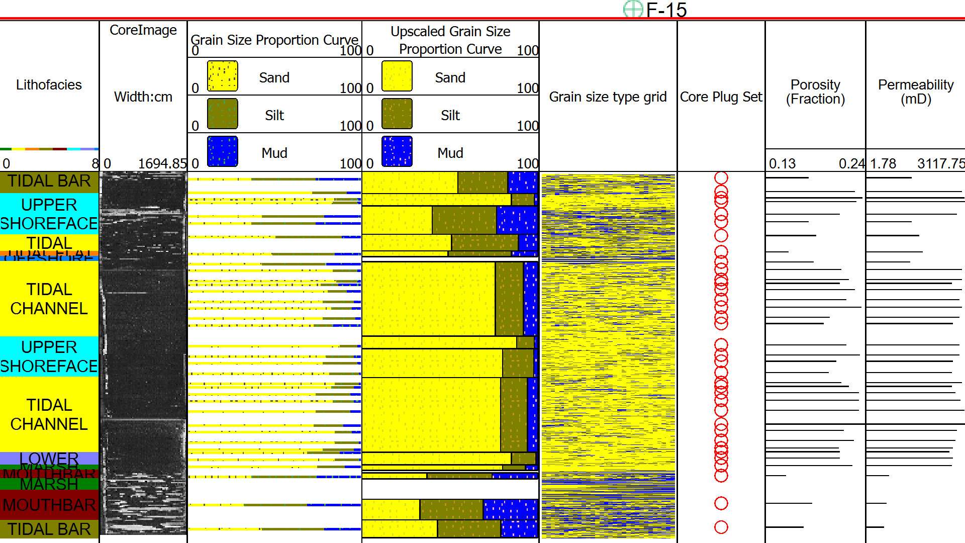
- Core-Plug Data Conditioning: The software offers conditioning to core-plug data, including critical parameters like porosity, permeability, sorting, and grain size classes. This feature allows for a more detailed and accurate representation of the reservoir’s physical properties, enhancing the reliability of the models.
- Advanced Flow-Based Upscaling: geomodelingAI incorporates a sophisticated flow-based upscaling method for the directional permeability tensor. This technique ensures that the upscaling of permeability data maintains its directional properties, which is crucial for accurate simulation of fluid flow in the reservoir.
- Specialized Stratigraphic Templates: The platform includes a range of stratigraphic templates designed for fluvial and deep-water depositional environments. These templates enable users to accurately represent the complex stratigraphy of these environments, capturing the nuances of different sedimentary structures.
- Sub-Seismic Heterogeneity Impact Analysis: geomodelingAI is adept at capturing the impacts of sub-seismic heterogeneity on fluid flow, even when using coarse grid models. This capability is vital for understanding and managing the finer details of reservoir heterogeneity that can significantly affect fluid dynamics.
- Integration of SBED and ReservoirStudio with AI: The tool amplifies the capabilities of SBED and ReservoirStudio by integrating them with advanced AI algorithms. This integration results in a powerful package that enhances every aspect of reservoir modeling, from data interpretation to simulation workflows.
- Seamless Workflow Integration: geomodelingAI seamlessly integrates with seismic and well data interpretations and production simulation workflows. This integration facilitates a cohesive and streamlined approach to reservoir analysis, combining detailed geological modeling with broader simulation techniques.
In summary, geomodelingAI represents a significant advancement in reservoir modeling technology. Its comprehensive template library, detailed data conditioning, advanced upscaling techniques, specialized stratigraphic templates, ability to capture sub-seismic heterogeneity, and seamless integration of AI with existing modeling capabilities make it an indispensable tool for any organization looking to enhance its reservoir analysis and decision-making processes.
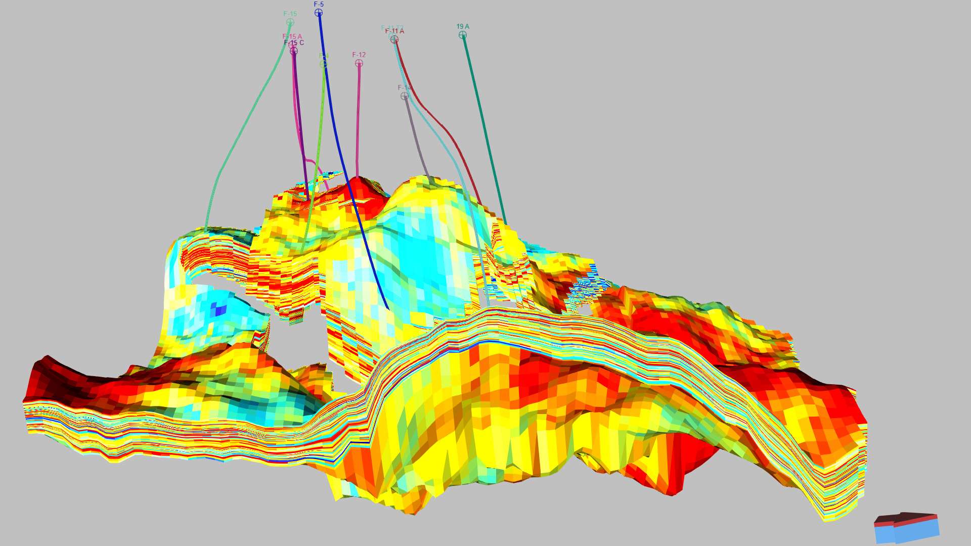
KVKH distributions for geomodelingAI
Enhancing Reservoir Analysis and Prediction
geomodelingAI software, a sophisticated component of the subsurfaceAI platform, offers a range of valuable deliverables that significantly enhance the process of reservoir analysis and prediction. By integrating advanced AI capabilities with the proven methodologies of SBED and ReservoirStudio, geomodelingAI provides comprehensive and accurate insights into reservoir characteristics. Here’s an expanded and detailed description of the major deliverables when using geomodelingAI:
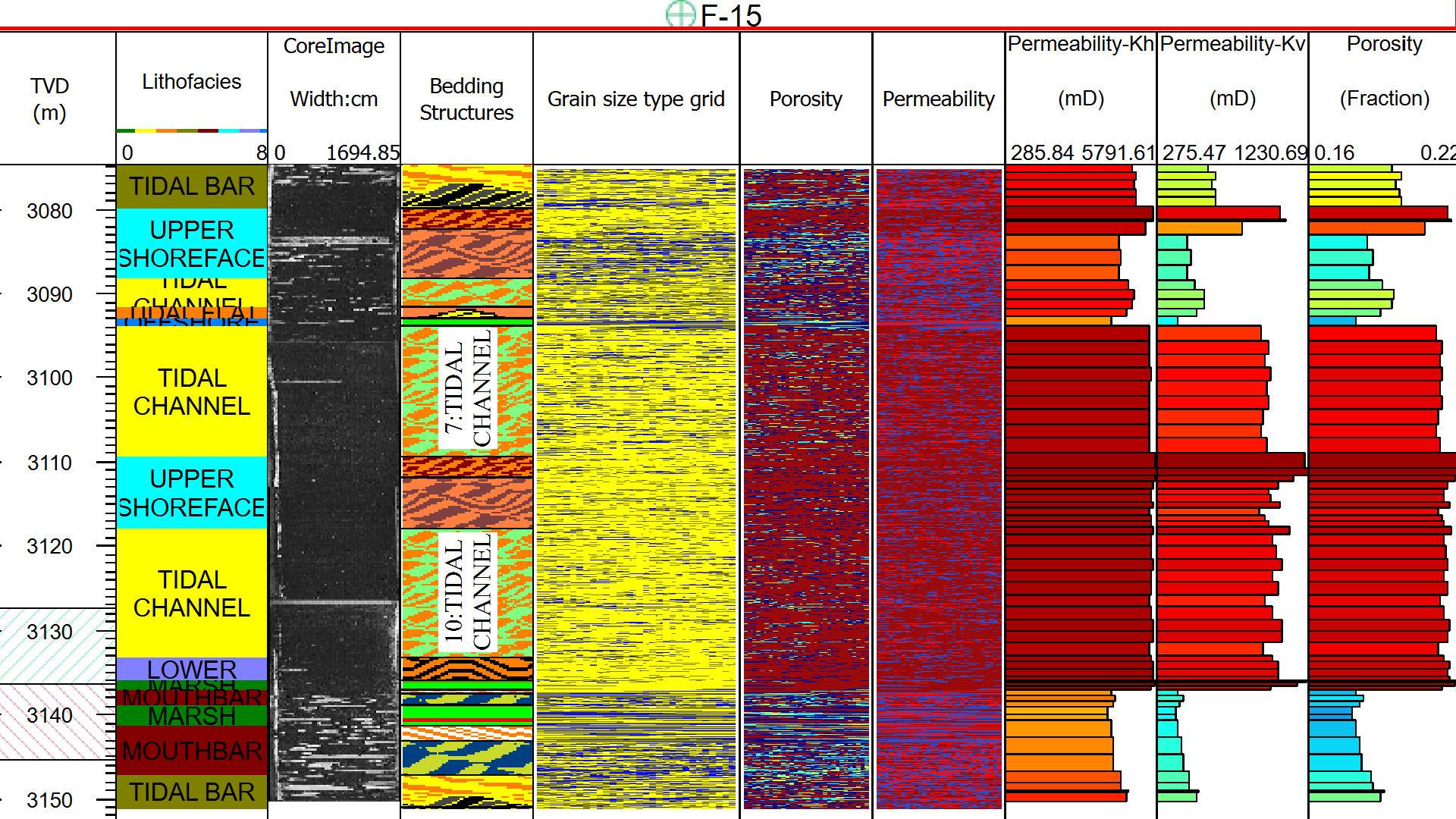
- Kv/Kh Distributions for Each Facies: geomodelingAI provides detailed Kv/Kh distributions for each facies within the reservoir. This information is crucial for understanding the vertical and horizontal permeability variations across different facies, enabling more accurate predictions of fluid flow and reservoir behavior.
- Directional Permeability Logs: The software generates directional permeability logs, offering detailed insights into the permeability characteristics of the reservoir along different axes. These logs are essential for understanding the directional flow capacities within the reservoir, aiding in optimizing extraction strategies.
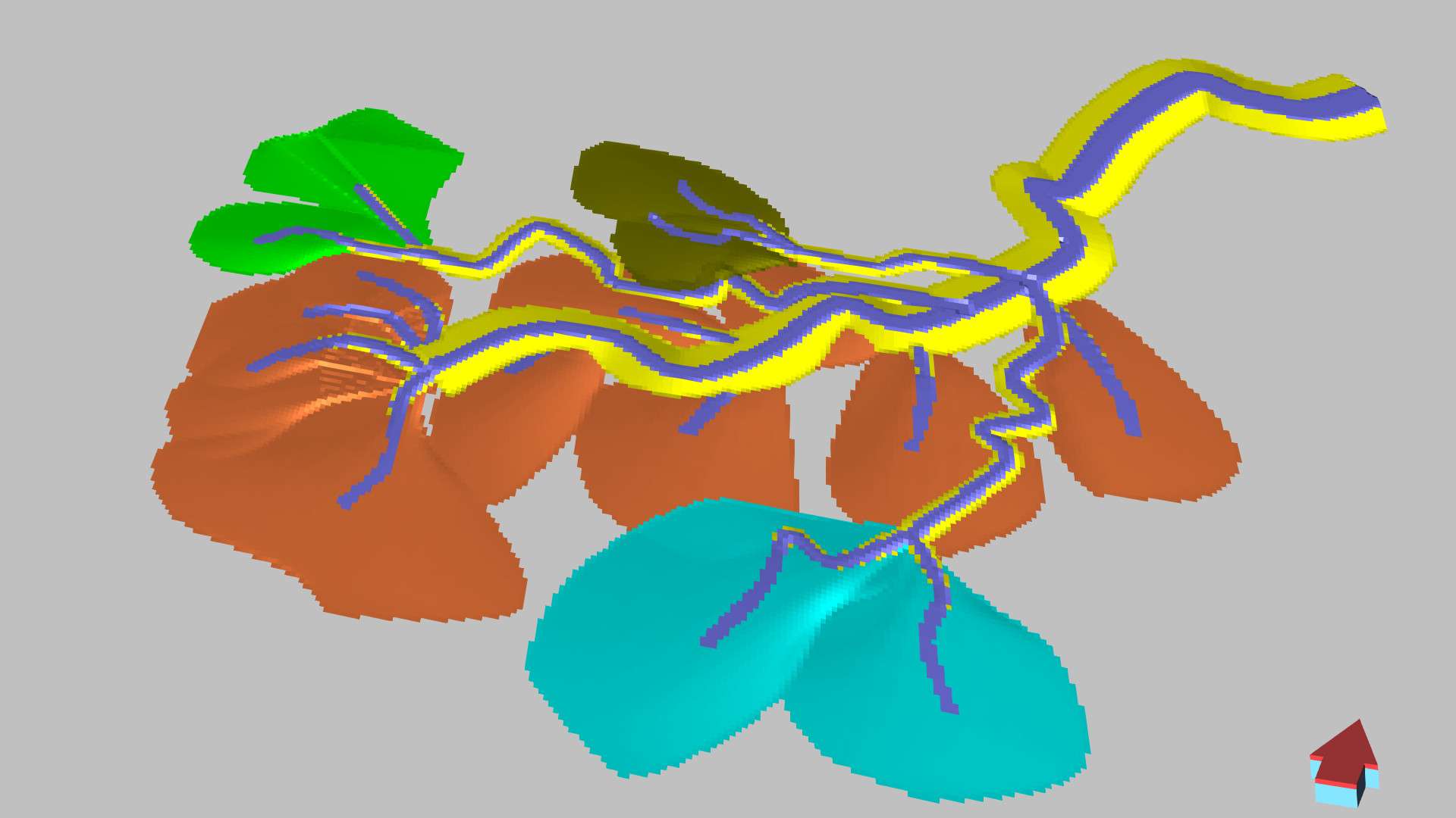
- Reservoir Model Grids Matching Depositional Environments: geomodelingAI creates reservoir model grids with layering that accurately match depositional environments. This level of detail ensures that the models reflect the true geological complexity of the reservoir, providing a more realistic basis for simulations and predictions.
- Directional Permeability Grids (Kx, Ky, Kz): The tool offers directional permeability grids (Kx, Ky, Kz) both before and after upscaling to flow grids. This feature allows for a comprehensive analysis of permeability in three dimensions, providing a thorough understanding of how permeability varies throughout the reservoir.
- Volumetric Distribution of Oil and Gas with Uncertainty Analysis: geomodelingAI delivers a detailed volumetric distribution of oil and gas in place, complete with uncertainty quantification across various percentiles (P10, P25, P50, P75, P90). This analysis is critical for effective resource estimation and risk assessment, allowing teams to make informed decisions with a clear understanding of potential variations in reservoir capacity.
In summary, the deliverables from geomodelingAI represent a significant enhancement in the field of reservoir modeling. Its ability to provide detailed Kv/Kh distributions, directional permeability logs, accurately layered reservoir grids, comprehensive permeability grids, and volumetric distribution with uncertainty analysis, makes it an invaluable tool for geoscientists and engineers. This comprehensive suite of deliverables ensures that users can confidently predict and manage reservoir performance with a high degree of precision.